Richmond Hill, Ontario, Canada, 15 Jan 2025– Beneath the areas inhabited by nearly one-fifth of the world's population, the ground is subsiding due to excessive groundwater withdrawal, which is altering the Earth's surface and posing risks to infrastructure. While sea level rise receives more attention, land subsidence occurs at a faster rate than rising oceans in many coastal cities, resulting in heightened flood risks that often go unnoticed until buildings show damage and water drainage becomes impaired.
A new Nature paper, co-authored by UNU-INWEH’s Global Environmental Intelligence Lab’s chief scientist, Dr. Manoochehr Shirzaei, provides the first high-resolution global map of this phenomenon. By processing over 200,000 satellite data points to measure minute changes in ground elevation, researchers have quantified how aggressive groundwater extraction is causing land to sink—or subside—at alarming rates across 12 million square kilometers of the planet's surface. The research exposes a direct correlation between the unregulated pumping of aquifers for agriculture and the physical compression of the earth, warning that without immediate intervention, 635 million people will be living on land that is sinking faster than sea levels are rising by 2040.
“Vertical land motion is the missing piece in global sea-level vulnerability assessments. Our findings show that subsidence isn’t a distant threat—it’s happening now, often at rates that exceed climate-driven sea-level rise in many river deltas,” said Dr. Shirzaei. “This means communities must tackle both global climate change and local land-management practices to meaningfully reduce risk.”
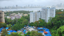
The study uncovers a stark geographic divide. While the crisis spans from California’s Central Valley to the North China Plain, the burden is overwhelmingly concentrated in Asia, which houses 86% of the population exposed to land subsidence. The analysis identifies the Indo-Gangetic Plain and key Asian deltas as "high-velocity" subsidence zones where land is sinking up to 20 times faster than the sea is rising. In contrast, regions with established groundwater governance, such as parts of Western Europe and managed basins in Japan, show stabilized ground levels, underscoring that this is a preventable policy failure rather than an inevitable geological fate.

Relative contributions of land subsidence and SLR in global deltas
"Ensuring the sustainable use of groundwater is not merely an environmental challenge, but a strategic imperative for global security," said Professor Kaveh Madani, Director of UNU-INWEH. "We cannot manage what we do not measure. It is critical that nations adopt rigorous impact monitoring to make the invisible costs of extraction visible. Only by understanding the real-time physical consequences of our water consumption can we implement the necessary policies to prevent infrastructure collapse and protect our aquifers for future generations."
To prevent this projected collapse, the authors urge policymakers to immediately implement satellite-based monitoring systems and enforce strict groundwater usage caps. Shifting agricultural practices in high-risk zones and investing in managed aquifer recharge technologies are no longer optional strategies, but essential requirements to keep cities standing and taps flowing.
Key Findings:
- 19% Global Reach: Land subsidence currently affects nearly 19% of the global population.
- Asian Epicenter: A staggering 86% of the population exposed to potential land subsidence resides in Asia.
- Rate Disparity: In identified hotspots, median subsidence rates (2–5 cm/year) exceed the global average sea-level rise (3.7 mm/year) by a factor of 10 to 15.
- Cropland Risk: Over 6 million square kilometers of productive cropland are at risk of losing drainage capacity, threatening global food security.
- Economic Threat: Approximately 9% of global GDP is located in areas susceptible to high rates of subsidence, with potential infrastructure losses estimated in the trillions.
Read the publication: Ohenhen, L.O., Shirzaei, M., Davis, J.L. et al. Global subsidence of river deltas. Nature (2026). https://doi.org/10.1038/s41586-025-09928-6
Media Contacts:
Kyra Bowman, UNU Head of Communications, bowman@unu.edu
Available for Interview:
Dr. Manoochehr Shirzaei – Chief Scientist, Global Environmental Intelligence Lab, UNU-INWEH – manoochehr.shirzaei@unu.edu
Prof. Kaveh Madani – Director, UNU-INWEH – madani@unu.edu
About UNU-INWEH
The United Nations University Institute for Water, Environment and Health (UNU-INWEH) is one of 13 institutions comprising the United Nations University (UNU), the academic arm of the United Nations. Established in 1996 through an agreement with the Government of Canada, UNU-INWEH, also known as the UN's Think Tank on Water is headquartered in the City of Richmond Hill, Ontario. UNU-INWEH specializes in addressing critical global security and development challenges at the intersection of water, environment, and health. Through research, capacity development, policy engagement, and knowledge dissemination, the institute bridges the gap between scientific evidence and the practical needs of policymakers and UN member states, with particular attention to low and middle-income countries. By collaborating with a diverse array of partners—including UN agencies, governments, academia, the private sector, and civil society—UNU-INWEH develops solutions that advance human security, resilience, and sustainability worldwide.