

On 4 September 2026, the United Nations General Assembly adopted a resolution entitled "Correct the Map: Rebalancing Global Cartographic Representation and Promoting Equitable Representation of the World's Regions, Particularly Africa". Introduced by Togo on behalf of the African Group and supported by the African Union, the resolution was adopted by an overwhelming majority of 164 votes in favour, one against, and six abstentions. The sole vote against the resolution was cast by the United States of America.
At first sight, the issue may appear too technical for an institution concerned with international peace, development, security and human rights, since maps are usually seen as neutral representations of geography. Yet the debate surrounding the Correct the Map initiative demonstrates precisely why such an understanding is incomplete. A map does not merely represent the world, it also participates in producing the ways in which the world is seen, taught, remembered and imagined.
This is where a constructivist reading becomes useful. The significance of the recent vote lies not simply in the relative accuracy of one cartographic projection compared with another, but in the politics of representation that accompanies it. The central question is therefore not only whether maps accurately depict geographical reality, but what kinds of memories, hierarchies and assumptions are reproduced through representations that become normalised over time.
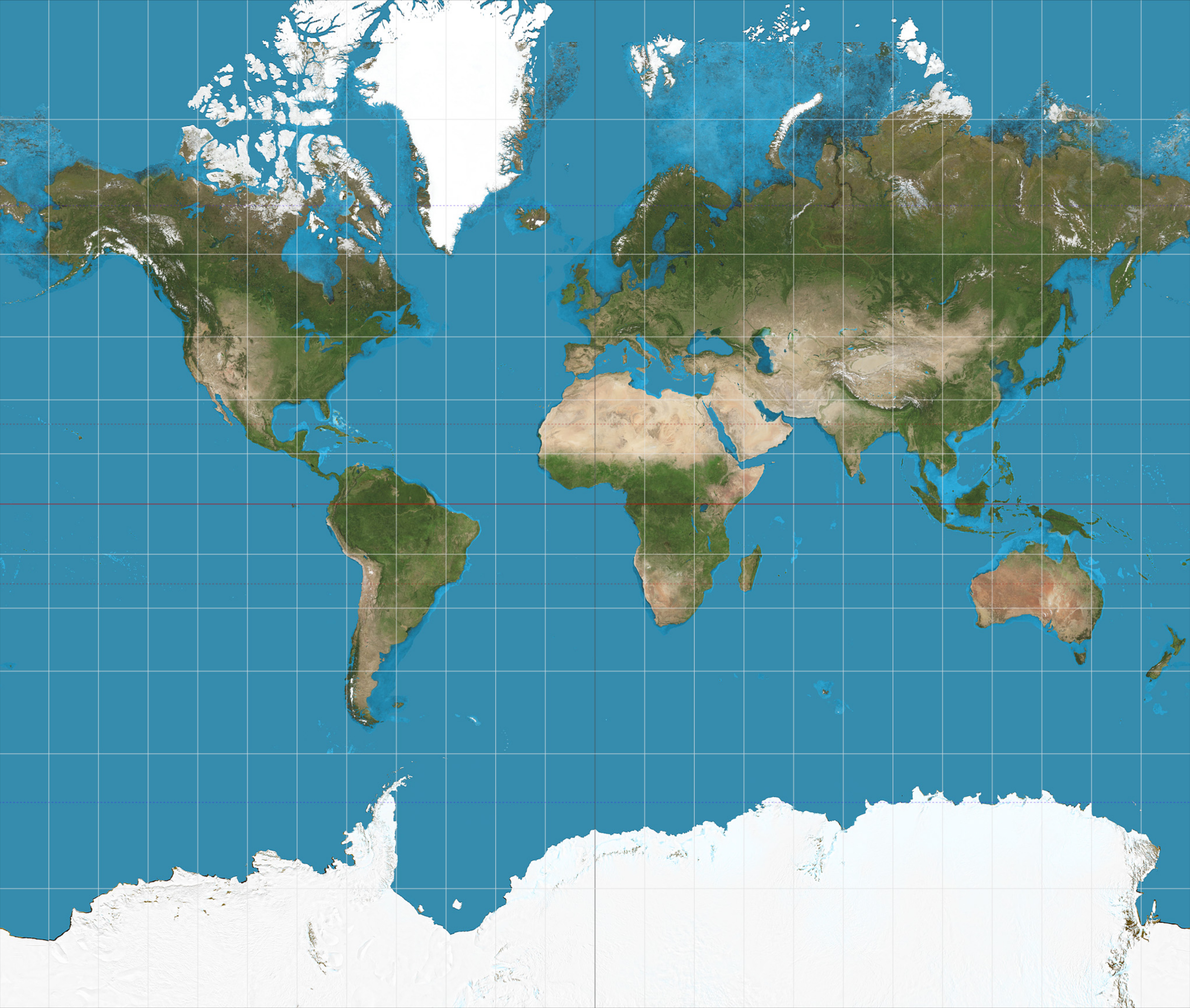
Figure 1. The Mercator projection, developed in 1569 for maritime navigation. Because its scale increases with distance from the equator, landmasses at higher latitudes (such as Greenland and Europe) appear disproportionately large relative to equatorial regions like Africa.
Source: Mercator projection SW, Strebe, Wikimedia Commons, CC BY-SA 3.0.
Maps as Constructed Tools and Political Narratives
The controversy surrounding the Mercator projection is a useful starting point. Developed in the sixteenth century for navigational purposes, it remains one of the most familiar ways of visualising the world, and the Correct the Map initiative does not dispute its navigational usefulness or seek to prohibit its use. The concern is what happens when such a projection becomes the standard representation of the world in textbooks and media. No flat map can reproduce the Earth without distortion. So, a map is never simply the world itself but a representation produced through a set of choices. Because the Mercator projection's scale increases with distance from the equator and regions at higher latitudes appear considerably larger than they are, Africa appears substantially smaller relative to Europe, North America and Greenland than in reality. This is a distortion that equal-area alternatives such as Equal Earth are designed to correct.
Yet the debate is not exhausted by cartographic accuracy. What matters from a constructivist perspective is the relationship between representation and social reality. When a representation is repeated for generations, it can cease to appear as a representation at all: it becomes the representation, its assumptions naturalised, its distortions familiar, its hierarchy invisible. Maps should therefore be approached as narrative instruments: they establish centres and peripheries, enlarge and minimise, and provide the frameworks through which people locate themselves within the international system. Political narratives, in other words, are not reducible to words.
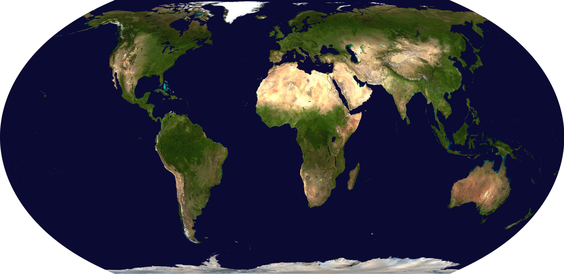
Figure 2. The Equal Earth projection, developed in 2018, preserves the relative area of landmasses. Compared with Figure 1, Africa's true scale becomes visible. (More than fourteen times the size of Greenland.)
Source: Blue-Marble-Equal-Earth, Doc James, Wikimedia Commons, CC0 1.0 Universal.
From Political Narratives to Memory Engineering
This observation is particularly relevant to the conceptualisation of memory engineering. Collective memory is usually discussed through explicitly political practices including ceremonies, monuments, or educational curricula through which states determine which events are remembered and which identities are legitimised. Memory engineering, however, need not depend on deliberately commemorative practices. It can also operate through the visual and institutional environments people encounter. A map in a classroom may seem a neutral pedagogical tool, but its repeated presence becomes part of the background against which reality itself is interpreted.
This does not require a conspiracy, nor that the original producer of a map consciously intended to construct a particular political memory. What matters is what happens when a representation survives beyond the context for which it was designed and becomes embedded in social institutions. Then it can acquire political meaning through repetition, institutionalisation and intergenerational transmission.
Two variants of this process can in fact be distinguished, and the Correct the Map case usefully illustrates both. The original entrenchment of the Mercator projection into classrooms, media and institutions was a largely diffuse and unintentional form of memory engineering. No single actor designed it to marginalise Africa, yet repetition and institutionalisation alone produced effects equivalent to those of a deliberately engineered memory. The Correct the Map initiative represents the opposite pole—an explicitly intentional and strategically pursued act of memory engineering, in which African countries consciously set out to contest an inherited representation and to institutionalise an alternative one through a General Assembly resolution. Read together, the two cases suggest that intentionality, institutionalisation and strategic orientation do not need to be present at the same stage or held by the same actor for memory engineering to occur. Rather, this is a diffuse and unintentional process of naturalisation can later become the object of a highly intentional and strategic act of correction.
Togo's Foreign Minister Robert Dussey made a version of this argument himself in introducing the resolution, insisting that mapping shapes education and collective perception, and linking the issue explicitly to historical memory and cognitive justice. The point, therefore, is not simply that one map is "wrong" and another "right". It is that representations acquire political consequences when they are normalised and transmitted as common knowledge.
The Geopolitics of Representation
The traditional world map has not emerged in a political vacuum. It has developed alongside changing configurations of power, and cartography has long been connected to empires and administrations. The political significance of the Correct the Map initiative lies in the fact that an African-led initiative is challenging a representation that has become globally familiar, proposing that the international community reconsider how the world is visually organised. This should be read as an attempt by actors historically positioned at the margins of dominant global representations to redefine the terms according to which those representations are produced.
The response of the United States is therefore revealing. Washington was the only government to vote against the resolution, arguing in its explanation of vote that the initiative was part of a broader "radical ideological project" and objecting in particular to its references to reparations and "cognitive justice". The American representative characterised the debate over sixteenth-century maps as a distraction from the genuinely pressing concerns of the United Nations. From a constructivist perspective, this rejection reads as another instance of the norm-challenging politics that has characterised US foreign policy since the early twenty-first century—most starkly illustrated by the 2003 Iraq War, when Washington's expansive doctrine of pre-emption provoked controversy over the authority to reinterpret established norms. A dispute over cartographic representation is obviously not equivalent to the use of military force. What connects the two cases is not their substance but a political repertoire that the willingness of a powerful state to challenge an emerging normative consensus when it does not correspond to its preferred understanding of international order.
Who Gets to Define the World?
The United States' position can also be read as an attempt to preserve an older geopolitical configuration in symbolic form. Maps cannot create material power on their own, but representations matter because power is partly sustained through the categories by which it is understood. A representation that places particular regions at the centre of the global picture shapes where importance and authority are seen to lie. This is not an argument that Washington consciously wants Africa to look smaller—it is subtler than that. Existing representations can sustain established understandings of order even as power shifts, and actors may preserve them because they remain consistent with the order in which they see themselves as dominant.
The striking feature of the 4 September vote is that this attempt at contestation produced almost complete diplomatic isolation. 164 states supported the resolution, and the United States was the only state to reject it. This situation is raising an uncomfortable question for Washington: has the geopolitical world already changed faster than its normative imagination? Normative power becomes less effective when the rest of the system no longer follows the actor exercising it, and the vote's margin matters symbolically. It can no longer be assumed that only the traditional centres of power define what counts as legitimate in global governance. This particular initiative emerged from an African state is equally significant—Togo placed an issue of representation, historical memory and knowledge production on the agenda of the General Assembly and built support across an overwhelming majority of its membership, challenging not only a cartographic convention but a deeper hierarchy over who possesses the authority to define how the world should be represented.
The Politics of Remembering the World
This brings us back to memory engineering. The politics of memory is fundamentally a politics of selection. Societies cannot remember everything, and therefore they develop mechanisms such as ceremonies, curricula, monuments, political speeches through which certain histories and spatial imaginaries are made more visible than others. So can maps. A map placed in a classroom is not a commemoration in the conventional sense, but repeated representations influence what future generations learn to regard as normal, becoming part of the symbolic infrastructure through which political memory is reproduced. This is precisely why the initiative is more significant than it first appears. Its implications do not depend on whether every country changes its maps, but on the deeper relationship between representation and memory—what kind of world are future generations being taught to see, and the answer is never entirely innocent.
The General Assembly's decision does not change the geographical structure of the planet, nor erase the historical utility of the Mercator projection. What it does is challenge the assumption that one inherited representation should remain dominant simply because it has become familiar. A world order can survive materially after the conditions that produced it change, and symbolically through the representations that continue to reproduce it. Memory engineering being one such mechanism, and the politics of the map is ultimately about who has the authority to decide what the world looks like.
An African-led initiative has challenged a representation inherited from a different historical era. The General Assembly has overwhelmingly endorsed that challenge, and the United States, once accustomed to occupying a central role in defining the parameters of international normative debate, has found itself standing alone against it. Perhaps the most consequential change is therefore not occurring on the map itself. It is occurring in the political imagination behind it.
Suggested citation: Görkem Yavuz., "A Constructivist Reading of Current Developments in World Politics: The "Correct the Map" Initiative," UNU-CRIS (blog), 2026-09-09, 2026, https://unu.edu/cris/blog-post/constructivist-reading-current-developments-world-politics-correct-map-initiative.