Roads are more than lines on a map. They are a fundamental layer of infrastructure that shapes mobility, accessibility, logistics, service delivery, and the everyday functioning of cities and regions. In remote sensing research, automatically identifying roads from satellite or aerial imagery is an important task with mutliple applications in urban planning, traffic management, and broader geospatial analysis (Bastani et al., 2018). At the policy level, better infrastructure knowledge is also relevant to the ambitions of SDG 9, concerning building and maintaining resilient infrastructure and to SDG 11 on supporting inclusive, safe, resilient, and sustainable cities and human settlements.
Yet there is a crucial gap evident in that many existing road datasets often support only part of the problem: some are designed to detect where roads are located in an image (binary road segmentation), while others are better suited to reconstructing how roads connect into a network (network reconstruction through centerlines). Fewer datasets bring these elements together with labels that distinguish different types of roads, such as major roads, secondary roads, and local roads, in one aligned resource. This makes it difficult for researchers to study road surfaces, network structure, and road hierarchy within a single benchmark. The challenge is particularly relevant in China, where openly accessible, high quality benchmark datasets for this kind of fine grained road analysis remain relatively limited.
To help address this need, researchers from Sun Yat-sen University and the United Nations University Institute in Macau, together with collaborators, have publicly released SYSU-HiRoads, a large scale, multi-level road dataset for remote sensing research (https://doi.org/10.5281/zenodo.18642747). Published with an open license, the dataset contributes a concrete piece of research infrastructure that others can access, inspect, reuse, and build upon. In that sense, the release reflects a broader commitment to making scientific knowledge more openly available, accessible, and reusable, which is central to open science (UNESCO, 2021, 2023).
This matters because it helps bridge a long standing divide between segmentation oriented and network oriented benchmarks. Instead of asking only where roads are, SYSU-HiRoads also helps support research on what kinds of roads they are and what roles they may play in a larger transport system. That makes the dataset potentially useful not only for computer vision and geospatial AI, but also for urban studies and transport related downstream tasks where hierarchy and functional differentiation matter (Tsigdinos et al., 2024). In practical terms, datasets of this kind may also help inform planning and decision making related to transport accessibility, infrastructure maintenance priorities, emergency routing, and the analysis of urban expansion.
From an open science perspective, this release is modest but meaningful. UNESCO defines open science as an approach that makes scientific knowledge openly available, accessible, and reusable, including publications, data, software, and infrastructures (UNESCO, 2021, 2023). Open science is not achieved simply by placing files online, and open data alone does not solve questions of equity, capacity, or uneven access. But openly releasing a carefully documented dataset with a persistent identifier, clear licensing, and reuse potential is still a practical contribution to that broader ecosystem (Wilkinson et al., 2016).
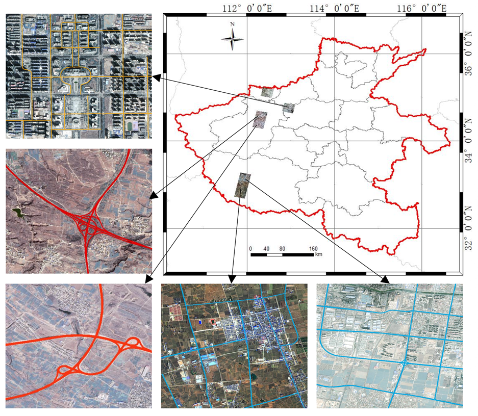
Figure 1: Coverage schematic of the SYSU-HiRoads dataset across Henan Province.
SYSU-HiRoads is derived from GF 2 satellite imagery covering Henan Province, China, with a spatial resolution of 0.8 meters. It spans approximately 3,631 square kilometres and contains 1,079 image tiles, each sized 1024 by 1024 pixels. As shown in Figure 1, the dataset covers a substantial geographic area across Henan Province, providing a broad empirical basis for road extraction and classification research.
More importantly, it provides aligned multi source annotations: pixel level road masks for dense road surface segmentation, vector level road centerlines for topology aware network reconstruction, and three level hierarchical road labels for fine grained classification. The dataset covers a range of scenes and road types, including urban roads, factory roads, overpasses, interchanges, roundabouts, highways, national roads, provincial roads, and county roads. Representative examples are presented in Figure 2, which illustrates both the diversity of scenes and the alignment between different annotation types.
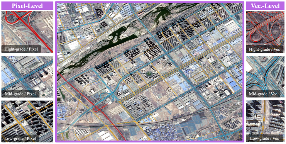
Figure 2: Representative examples of SYSU-HiRoads, including road imagery and aligned annotations.
Alongside the dataset, the team also presents RoadReasoner, a vision, language, and geometry based framework for automatic fine grained road hierarchy classification. As illustrated in Figure 3, the framework combines road extraction, centerline reconstruction, and multimodal reasoning to infer road grades in a more interpretable way. In recent experiments, RoadReasoner achieved 72.6% overall accuracy, 64.2% F1 score (a standard metric that reflects how well a model balances correct positive predictions and missed cases), and 60.6% segmentation accuracy for hierarchy mapping. The associated extraction pipeline also outperformed several baselines on key segmentation metrics on SYSU-HiRoads.
While the dataset release is the central contribution here, the methodological component is also useful because it demonstrates how an openly shared dataset can be used to develop, test, and compare new approaches for road analysis in a more reproducible way.
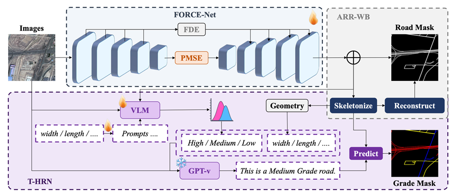
Figure 3: Overview of the RoadReasoner framework.
SYSU-HiRoads is an example of how research teams can translate the values of openness into concrete scholarly practice. Better open research resources for understanding infrastructure can support the scientific and technical foundations needed for work related to resilient infrastructure, sustainable transport, and urban analysis, all of which connect in different ways to the sustainable development goals. Such releases expand the pool of shared knowledge on which future research, collaboration, and evidence based applications can be built.
At a time when calls for open, transparent, and reusable science are growing, releasing high quality datasets remains a key way to contribute to the research commons. SYSU-HiRoads does exactly that. It offers the remote sensing and geospatial AI communities a new benchmark resource, while also showing how collaborative research can generate public value through openness.
This is a useful reminder that advancing digital innovation for sustainable development is not only about building new models. It is also about making the underlying knowledge base more accessible to others. We hope SYSU-HiRoads will be useful to researchers working across remote sensing, geospatial AI, transport, and urban studies, and we welcome interest from those who may wish to use the dataset, test new methods, or explore future collaboration.
References
Bastani, F., He, S., Abbar, S., Alizadeh, M., Balakrishnan, H., Chawla, S., Madden, S., & DeWitt, D. (2018). RoadTracer: Automatic extraction of road networks from aerial images. In Proceedings of the IEEE/CVF Conference on Computer Vision and Pattern Recognition (pp. 4720–4728).
Tsigdinos, S., Salamouras, G., Chatziioannou, I., Bakogiannis, E., & Nikitas, A. (2024). A worldwide review of formal national street classification plans enhanced via an analytical hierarchy process: Street classification as a tool for more sustainable cities. Cities, 154, 105371. https://doi.org/10.1016/j.cities.2024.105371.
UNESCO. (2021). UNESCO recommendation on open science. UNESCO. https://www.unesco.org/en/open-science?hub=686.
UNESCO. (2023). Open science outlook 1: Status and trends around the world. UNESCO. https://doi.org/10.54677/GIIC6829.
Wilkinson, M. D., Dumontier, M., Aalbersberg, I. J., Appleton, G., Axton, M., Baak, A., Blomberg, N., Boiten, J., da Silva Santos, L. O. B., Bourne, P. E., Bouwman, J., Brookes, A. J., Clark, T., Crosas, M., Dillo, I., Dumon, O., Edmunds, S., Evelo, C., Finkers, R., … Mons, B. (2016). The FAIR Guiding Principles for scientific data management and stewardship. Scientific Data, 3, 160018. https://doi.org/10.1038/sdata.2016.18.
Suggested citation: Jia An LIU, Yiping Chen., "Mapping Roads More Openly: Releasing SYSU-HiRoads for Remote Sensing Research," UNU Macau (blog), 2026-03-19, 2026, https://unu.edu/macau/blog-post/mapping-roads-more-openly-releasing-sysu-hiroads-remote-sensing-research.