Background
Cities are complex and dynamic systems that face various interconnected challenges such as urbanisation, climate change, environmental degradation, social inequality, and public health issues. To address these challenges, there is a need for innovative and evidence-based solutions that can leverage the potential of geospatial big data.
Geospatial big data refers to the large and diverse datasets that capture the spatial and temporal characteristics of urban phenomena, such as population, mobility, land use, infrastructure, environment, and health. This data can be derived from various sources, such as remote sensing, geographic information systems (GIS), social media, mobile devices, sensors, and crowdsourcing.
Geospatial big data can provide valuable insights into the patterns, processes, and impacts of urban hazards, such as air pollution, heat stress, flooding, crime, and disease outbreaks. Additionally, it can support the development and evaluation of urban policies, planning, and design interventions that aim to enhance the health and sustainability of cities and their inhabitants.
However, geospatial big data also poses significant challenges and opportunities for urban researchers, practitioners, and stakeholders. These include the availability, accessibility, quality, integration, analysis, visualisation, and communication, as well as the ethical, legal, and social implications of its use. Therefore, there is a need for a multidisciplinary and collaborative platform that can facilitate the exchange of knowledge, experience, and best practices on the applications of geospatial big data in urban contexts, especially in relation to urban hazards and their mitigation.
Objectives
The main objective of this workshop is to bring together experts and stakeholders from various disciplines and sectors to discuss and explore the current state, challenges, and opportunities of utilising geospatial big data for healthy and sustainable cities, with a focus on urban hazards and their mitigation.
The expected outcomes of this workshop are:
- A network of experts and stakeholders who are interested and engaged in the topic of geospatial big data for healthy and sustainable cities.
- A roadmap for future research, practice, and collaboration on the topic of geospatial big data for urban hazards and their mitigation.
Speakers

Prof. Dong Liu
Presentation
Promoting Healthy and Sustainable Cities through Geospatial Data Analytics
Bio
Prof. Dong Liu is a Research Assistant Professor jointly appointed at the Institute of Space and Earth Information Science (ISEIS) and the Institute of Future Cities (IOFC) at The Chinese University of Hong Kong (CUHK). Prior to joining CUHK, Prof. Liu obtained his Ph.D. in Geography from the University of Illinois Urbana-Champaign in the United States in 2021. After completing his doctoral degree, he served as a Postdoctoral Research Fellow at the Human Environments Analysis Laboratory at the University of Western Ontario in Canada and received the Trainee Award from the Children's Health Research Institute. His research focuses on examining urban mobility, location accessibility, travel behaviour, physical activity, and environmental health through geospatial analysis methods. He has coordinated and participated in multiple projects funded by the Public Health Agency of Canada, the Heart and Stroke Foundation of Canada, the Canadian Institutes of Health Research, and the Ontario Ministry of Health. Prof. Liu has published nearly 30 articles in high-level SCIE/SSCI journals in relevant fields. His current main research project is on the health impacts of personal environmental exposures funded by the Research Grants Council of Hong Kong.

Dr Zihan Kan
Presentation
Concurrent Exposures to Air Pollution, Noise, and Greenspace: Investigating Spatial Patterns and Relationships Using Real-Time GPS and Mobile Sensing Data
Bio
Dr Zihan Kan is an Assistant Professor at the Department of Geography and Resource Management, The Chinese University of Hong Kong (CUHK). Her research is dedicated to exploring the intricate relationship between human activities and the environment, employing cutting-edge geospatial analytical methods. Kan’s work focuses on addressing crucial issues such as the impact of the environment on human health, with a particular emphasis on movement flows, transportation-related emissions and traffic congestion, as well as the built environment. An essential aspect of her research involves harnessing large movement datasets, including GPS trajectories, as well as a diverse range of complementary data sources such as individual GPS tracking, mobile sensing, remote sensing, land use, built environment, and activity travel diaries. By integrating these comprehensive datasets, she gains valuable insights into the complex dynamics between human behaviour and environmental factors. Kan has been recognized for her outstanding contributions and has successfully secured funding for her projects from esteemed organizations like the National Natural Science Foundation of China and the Hong Kong Research Grants Council.

Dr. Jianwei Huang
Presentation
Associations between COVID-19 risk and multiple environmental exposures: a study using individual-level GPS-based real-time sensing data.
Bio
Dr. Jianwei Huang is currently a postdoctoral fellow at the Institute of Space and Earth Information Science (ISEIS), the Chinese University of Hong Kong, where he also obtained his PhD in Earth System and Geoinformation Science in 2023. He holds a M.Sc. degree at Nanjing Normal University, a M.Sc. degree at Salzburg University, and a B.Sc. degree at Yunnan University. His research interests focus on understanding how the urban environment would shape people's daily life and thus further influence their health outcomes. He also focuses on understanding people’s geoprivacy concerns for and acceptance of different public health measures that rely on their daily mobility data in various social and cultural contexts. He has extensive experience participating in various projects funded by the Hong Kong Research Grants Council (RGC) and the Innovation and Technology Fund. Currently, he is working on projects examining health impacts from individual environmental exposure funded by the Hong Kong Research Grants Council.

Dr. Jianying Wang
Presentation
Investigating the Neighborhood Effect Averaging Problem (NEAP) in Greenspace Exposure: A Study in Beijing
Bio
Dr. Jianying Wang is currently a postdoctoral fellow in the institute of Space and Earth information Science at the Chinese University of Hong Kong. He is currently supported by the Hong Kong Research Grants Council (RGC) Postdoctoral Fellowship. He received his PhD in GlScience from the Peking University and was a visiting PhD student in urban planning and policy at the Tufts University. He specializes in the field of geospatial big data, with a particular focus on social equity, urban human mobility, and sustainable transportation. His research encompasses accessibility models, human mobility modeling, complexity theories, and spatiotemporal mining algorithms. The primary objective of his work is to deepen our understanding of how socioeconomic factors, such as gender, income, race, ethnicity, and religion, influence the everyday mobility patterns and perceptions of urban residents concerning the built environment, with the aim of informing policies and strategies that promote inclusive and sustainable urban development.
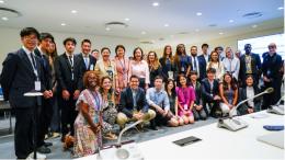
Agenda
The workshop will be held at UNU IIST in Macau.
Session 1: Introduction and Keynote Presentations. This session will provide an overview of the workshop theme and objectives, as well as the keynote presentations by invited speakers who are leading experts in the field of geospatial big data and urban hazards. The keynote presentations will cover the following topics:
Session 2: Plenary Session and Wrap-up. This session will reconvene the participants to share and synthesize the main findings and conclusions of the breakout group discussions, as well as to identify and prioritize the key action points and recommendations for the next steps. The workshop organizers will also provide a summary and evaluation of the workshop, as well as the information on the publication of the workshop proceedings and the follow-up activities.